For my Sunday hikes, I’ve struggled to find a nearby, appropriate trail system. My first hike, at Mt Airy, was disappointingly flat and also confusing as hell. Even armed with a trail map, I found myself making wrong turns that dumped me back on the road (and out of the trail network). After a couple disappointing hikes, I tried the Dr Norman and Martha Adair Wildlife Management Area, in Boone County, Kentucky. I was hoping for some steep hills. I found a few, but mostly I found biting flies, thorns, and a hunter. Thankfully, he shot a squirrel instead of me. I was a bit worried about being mistaken for an animal as I thrashed my way along the overgrown trails. By the time I made it back to my car, I probably looked as if someone shot me. I was so bloody from pushing through wild roses and blackberry bushes that I had to wipe down with a tissue and my remaining water, or risk staining Beefy’s upholstery. Mt Airy didn’t seem so bad after my Kentucky adventure.
I returned to Mt Airy with a plan. I’d enter at the Colerain trail and choose the left fork of every intersection to maximize my distance on the trails. I also planned to repeat any steep sections multiple times to increase my elevation climbed. This plan was successful. I managed roughly eight miles on the trails and discovered the Stone Steps. The Stone Steps are a series of flat stones set into the trail to climb roughly 200 vertical feet. They are uneven and crumbling with age. The steps become steeper as one climbs and I was huffing and puffing by the time I reached the top. Delighted, I climbed back down and repeated them three more times. While there are plenty of outdoor stairs in Cincinnati (especially in the Mt Adams area), I prefer the Stone Steps for Pikes Peak training. The uneven rise and footing is a closer approximation to what I’ll be facing on the mountain than a regular staircase. I’ll certainly be returning to Mt Airy for more of my training hikes and adding more Stone Steps repetitions.
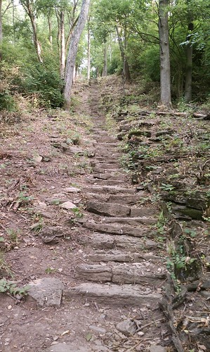
The Stone Steps
Mt Airy seems to be the best option for my training in Cincinnati, but I was excited to try someplace new while Beefy and I vacationed in Michigan. For my July 1st hike, I headed to the Warren Dunes State Park. My 10 mile hike was a combination of wandering up and down the dunes (quite strenuous in the loose sand!), speed walking the proper trails, and marching along the lakefront. I wish I could return for another training hike, but the five hour drive isn’t going to work with my schedule.
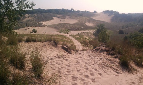
Warren Dunes
It looks like I’ll be back at Mt Airy for future hikes, but I’d love to hear any suggestions from locals. Where can I hike 8 – 12 miles and get a good elevation gain in the Cincinnati area?
Sporty Sunday is a recurring feature in which I share my fitness routine and offer and solicit advice. While this content might seem a little out of place in an outfit diary, a healthy, strong body is the foundation of my wardrobe. I hope to inspire my readers to be fit as well as stylish!
3 comments:
Something to consider. Split your workouts into two components. Run the hills in an urban setting, such as: starting at Allyn's Cafe and running up to Alms Park, or starting downtown and running up to Mt Adams. Do trail work on whatever you can find. Then plan a weekend in Gatlinburg to run one of the seven trails up to Mt LeConte, the trails are from 5 to 9miles one way, and are an easy day trip. Plus Mt LeConte is 6,600 ft high.
Check out the book "60 Hikes Within 60 Miles: Cincinnati: Including Clifton Gorge, Southeast Indiana, and Northern Kentucky" by Tammy York. It provides all the information you need in terms of elevation, distance, difficulty levels, maps, etc. It's a great reference guide! Happy hiking!
We're training for the Grand Canyon and have been driving 2 hours south to Red River Gorge, KY.
Post a Comment